
What is Papago Park?
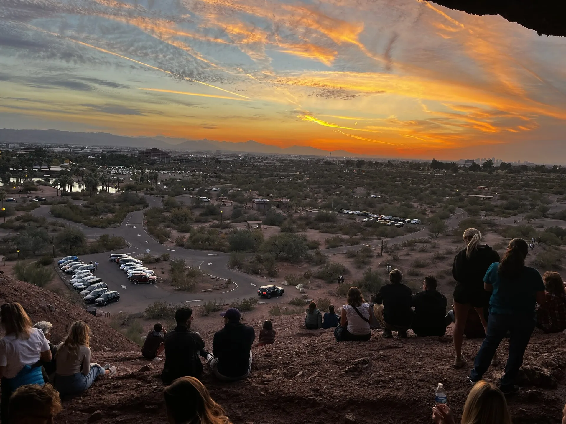
You have already seen it. The red sandstone buttes on the approach into Sky Harbor, the ones that look like something melted and then hardened again — that’s Papago. And the hole in the middle of the nearest one, full of tiny human silhouettes at sunset, is Hole-in-the-Rock.
Papago Park covers roughly 1,500 acres at 625 N. Galvin Parkway, split between Phoenix and Tempe. It is not in Scottsdale. It is, however, about ten minutes from south Scottsdale and fifteen from Old Town, which makes it the nearest large desert park for a big slice of the city and a standard destination for Scottsdale families who want buttes without a mountain.
The park is unusually loaded for something that’s free to enter. Hole-in-the-Rock, whose eroded chambers — geologists call the pockets tafoni — show evidence of Hohokam use as a solar calendar. Hunt’s Tomb, the white pyramid holding Arizona’s first governor. A chain of stocked fishing lagoons. Flat, sandy, wonderfully easy trails looping between the buttes. Ramadas, ball fields, a golf course on the edge, and the Crosscut Canal path running along the park’s eastern flank. Inside the boundary, two of Arizona’s best-known paid attractions: the Desert Botanical Garden, founded here in 1939, and the Phoenix Zoo, opened in 1962 on the grounds of a Depression-era fish hatchery.
The whole thing used to be a national monument. For three years the ground on its northern edge held German prisoners of war. Papago has had more lives than most cities, and it still charges nothing to walk through any of them.
How to do Papago Park right
Go at sunrise, not sunset. This is the single highest-value piece of advice about this park. Everyone piles into the small Hole-in-the-Rock lot in the hour before dark, and at sunset the buttes are backlit — you get a silhouette and a queue. At sunrise the low light lands on the sandstone, turns it genuinely red, and you’ll have the chamber nearly to yourself. Then watch the hours: trails are open 5 a.m. to 11 p.m., but the parking areas east of Galvin Parkway close at 7 p.m., so plan your exit.
Pick a walk, because there are several. The Hole-in-the-Rock path is a few hundred yards and works for essentially anyone. The trails around the larger buttes give you two to four flat, sandy miles with almost no elevation — the friendliest real desert walking in the metro area, and a good option on days when Camelback would be a bad idea. The paved climb to Hunt’s Tomb is five minutes and delivers a better view than its effort deserves.
Summer is the catch. Flat and exposed means the sand and rock bake. By 9 a.m. in June this park is genuinely hazardous, and it has none of the elevation that buys you a breeze. Dawn only, water in hand, and read the summer sunrise hiking rules. In the wet months, the monsoon field manual applies — the washes between the buttes run fast and the sand turns to grease.
Fishing and family logistics. The lagoons are part of Arizona’s urban fishing program — catfish and bass most of the year, trout stocked in winter — and licenses are required for adults. Ramadas near the water are first-come and the good ones go early on weekends. Leashed dogs are welcome on the trails, which is more than Camelback offers.
Stack it with the paid stuff. The Desert Botanical Garden and Phoenix Zoo are both inside the park and both charge admission; either one plus a butte walk is a full, easy day out of Scottsdale. If you’d rather stay on the Scottsdale side of the line, Eldorado Park and Vista del Camino cover the lake-and-lawn version of the same afternoon, and Papago Rotary Park borrows the name without the buttes.
A national monument, a fish hatchery, a prison camp and a zoo
The buttes are the oldest thing here and the least changed. That coarse red rock is arkosic conglomeratic sandstone, assembled roughly 6 to 15 million years ago out of material eroding off a granite range that no longer exists. Water and salt then hollowed the pockets and chambers — tafoni — that give Hole-in-the-Rock its name and its openings, including a second hole in the ceiling of the main chamber.
The Hohokam lived around these buttes for something like a thousand years, and they appear to have paid close attention to that ceiling hole. Inside the chamber, researchers have documented a worn, ground-down patch on the rock — the kind of surface produced by deliberate, repeated grinding — positioned where sunlight through the opening would strike at the solstices and equinoxes. The reading is that Papago’s most photographed landmark was also a calendar, used to time a farming year in a place where getting the planting date wrong meant starving. It’s interpretation, carefully argued rather than proven, and it’s the most interesting thing about the rock.
The modern paperwork begins in 1879, when the land was designated a reservation for the Maricopa and Pima people — the source of the name “Papago,” an exonym the park inherited and never shed. In 1914 the buttes became Papago-Saguaro National Monument, a genuine unit of the young national monument system. It didn’t last: Congress abolished the designation in 1930, one of the very few national monuments ever undone, and the land moved to state and eventually city hands.
What followed was a century of the park being handed whatever the Valley needed. Governor George W. P. Hunt — Arizona’s first, a seven-term populist who liked being seen — built a startling white pyramid on a butte in 1931 to entomb his wife Helen, and joined her there in 1934; the tomb is now on the National Register. In 1932, federal Depression-era money built a bass hatchery in the park’s ponds. During the Second World War the park’s northern edge became a military training ground and then Camp Papago Park, the German POW camp whose 1944 tunnel escape remains the largest Axis breakout on American soil. In 1959 the state sold a big portion to Phoenix; the hatchery closed and, in 1962, the Phoenix Zoo opened on its grounds. The Desert Botanical Garden had already been founded in the park back in 1939 by a group of cactus enthusiasts who feared the desert flora was being bulldozed faster than it was being recorded.
The result is a park that functions as the Valley’s attic: a geology lesson, an archaeoastronomy site, a governor’s tomb, a failed national monument, a war relic, a zoo, a botanical garden and a place to catch a stocked catfish, all inside one boundary and mostly free. For Scottsdale, it’s also a boundary marker — the southwest corner of the city’s world, where the grid gives way to buttes and the Crosscut Canal path threads north along the park’s edge toward the canal network that eventually becomes the Greenbelt’s neighborhood.
Why it matters
Scottsdale has spent thirty years and hundreds of millions of dollars assembling a preserve in the mountains. Papago is the other model: a piece of desert that survived by being useful to everyone in turn — monument, hatchery, prison camp, zoo, fishing hole — and kept its buttes intact through all of it. It is the easiest desert in the Valley to walk, the best sunrise within fifteen minutes of Old Town, and the one place where you can stand inside a Hohokam calendar with a Phoenix Zoo train whistle going off behind you. Go early, and let the crowd have the sunset.