Skip to content
Visiting or new to Scottsdale? Start here
Scottsdale.tips
Families • October 18, 2026

Scottsdale Sports Complex Field Maps: Reata, Bell94, the Sports Complex and WestWorld

Drawn field maps of Scottsdale's tournament fields, and the rule that sorts them: Fields 1–10 are at the Scottsdale Sports Complex on Princess Drive, 11–16 at Bell94 on Bell Road, 17–21 at Reata on McDowell Mountain Ranch Road, and WestWorld's grass is numbered by each event's organizer. Where each field is, where to park, and which lot is the short walk.

By • 6 min read
Illustration for Scottsdale Sports Complex Field Maps: Reata, Bell94, the Sports Complex and WestWorld FINISH 1317 13.1

Every cool-season Saturday, somebody’s parent is standing in the wrong parking lot holding a schedule that says Field 19. It happens because Scottsdale numbers its tournament fields straight through three different parks, and the schedule rarely says which park. This note fixes that: the one rule that tells you where your game is, then a drawn map of each complex with the field numbers, the lots and the restrooms. Each map also lives on its park’s guide, and each one downloads as a file you can print or send to the team chat.

Which complex is my game at?

Read the field number, then:

  • Fields 1 to 10: the Scottsdale Sports Complex, 8081 E. Princess Drive, at Hayden Road and Bell Road. Fields 1 to 6 are lighted; 7 to 10, north of Princess Drive, are not.
  • Fields 11 to 16: Bell94 Sports Complex, 9390 E. Bell Road, at 94th Street. All six are lighted.
  • Fields 17 to 21: Reata Sports Complex, 9809 E. McDowell Mountain Ranch Road, at Thompson Peak Parkway. All five are lighted.
  • “WestWorld” with no number, or a number above 21: the grass at WestWorld, 16601 N. Pima Road, where the organizer lays out and numbers the fields for each event. Use the organizer’s map.

The three city complexes are close: Bell94 is about a mile and a half east of the Sports Complex along Bell Road, and Reata about a mile east and south of Bell94. Close is not the same as walkable with a cooler and a canopy, so check the park before you leave the hotel. On tournament days the organizer’s map is the final word, because a big event can rename or re-stripe fields; every number on these maps matches the City of Scottsdale’s own facility maps.

Which park is my game at?Locator map of North Scottsdale’s four tournament venues. The Scottsdale Sports Complex, fields 1 to 10, is farthest west, at Hayden Road and Bell Road beside the Loop 101. Bell94, fields 11 to 16, is about a mile and a half east on Bell Road at 94th Street. WestWorld’s grass field is southwest of Bell94, off Pima Road beside the Loop 101. Reata, fields 17 to 21, is farthest east, about two and a half miles from the Sports Complex, at McDowell Mountain Ranch Road and Thompson Peak Parkway.Which park is my game at?Fields 1–10, 11–16 and 17–21 are three parksLoop 101Hayden RdBell RdThompson Peak PkwySports ComplexFields 1–10Bell94Fields 11–16ReataFields 17–21WestWorldNo fixed numbersN0½ mileStreets: OpenStreetMap contributors ·checked October 2026
Streets: OpenStreetMap contributors · checked October 2026.

Scottsdale Sports Complex: Fields 1 to 10

The oldest and biggest of the three, 71 acres between Hayden Road and 82nd Street, with Princess Drive cutting through the middle. South of Princess, lighted Fields 1 to 4 make a square (1 and 2 on the north side, 4 and 3 below them) and lighted Fields 5 and 6 run along Hayden Road. North of Princess are the four unlighted fields, 7 and 8 at the west end and 9 and 10 at the east end, with a drop-in area between them.

Park in the center lot from Bell Road for Fields 1 to 6; it sits between the two groups. The east lot off 82nd Street is the short walk to Fields 2 and 3; the small lots north of Princess serve 7 to 10. The playground is by the roundabout just north of Princess.
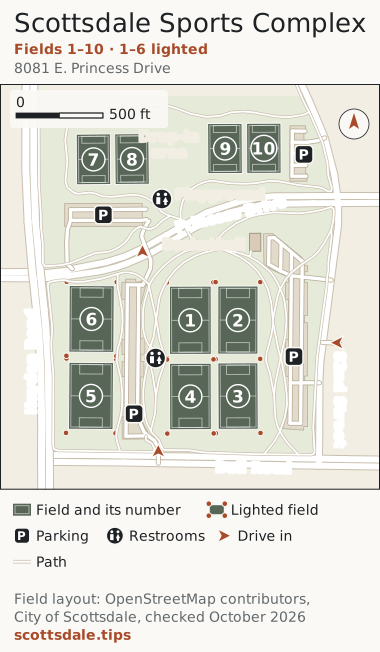
Scottsdale Sports Complex field mapMap of the Scottsdale Sports Complex, 8081 E. Princess Drive, the block between Hayden Road and 82nd Street just north of Bell Road. Princess Drive cuts across it. South of Princess, lighted Fields 1 to 4 make a square inside an oval path: 1 and 2 on the north side, 4 and 3 below them, each pair west to east. Lighted Fields 6 and 5 run north to south along Hayden Road. Between the two groups are the center parking lot, entered from Bell Road, and the restroom and office building. North of Princess are the four unlighted fields: 7 and 8 at the west end, 9 and 10 at the east end, with a drop-in area between them. A second restroom building and the playground sit by the roundabout north of Princess. The basketball court is just south of Princess near 82nd Street, beside the long east lot, which is entered from 82nd Street.Scottsdale Sports ComplexFields 1–10 · 1–6 lighted8081 E. Princess Drive12345678910Hayden RoadBell RoadPrincess Drive82nd StreetPlaygroundPPPPDrop-inareaBasketballN0500 ftField and its numberLighted fieldPParkingRestroomsDrive inPathField layout: OpenStreetMap contributors,City of Scottsdale, checked October 2026scottsdale.tips
Download the field map (SVG, prints at any size). Scottsdale Sports Complex guide . Field numbers match the city’s facility map (PDF); on tournament days the organizer’s map wins.

Bell94: Fields 11 to 16

The newest and most compact: six lighted fields in one block, every one of them a five-minute walk from a car. Field 11 is nearest Bell Road and 12 is just north of it; 13 and 14 sit side by side in the middle row and 15 and 16 along the north edge, 13 and 15 on the west.

Park in the long main lot on the west side, from Bell Road or, on a busy morning, from the quieter 91st Street end. The small lot off 94th Street is the shortest walk to 12, 14 and 16. The restrooms and office are on the plaza between 12 and 13, and The Thumb is directly across Bell Road for the meal afterward.
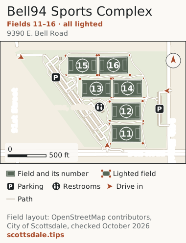
Bell94 Sports Complex field mapMap of Bell94 Sports Complex, 9390 E. Bell Road, at Bell Road and 94th Street. Six lighted fields, numbered 11 to 16, fill the block east of the main parking lot. Field 11 is nearest Bell Road and Field 12 is just north of it. Fields 13 and 14 sit side by side in the middle row, 13 to the west, and Fields 15 and 16 run along the north edge, 15 to the west. The long main lot runs diagonally up the west side; drive in from Bell Road at its south end or from 91st Street at its north end. A second, smaller lot opens off 94th Street on the east side. The restroom and office building is on the plaza halfway along the main lot, between Fields 12 and 13.Bell94 Sports ComplexFields 11–16 · all lighted9390 E. Bell Road111213141516Bell Road94th Street91st StreetRestrooms, officePPN0500 ftField and its numberLighted fieldPParkingRestroomsDrive inPathField layout: OpenStreetMap contributors,City of Scottsdale, checked October 2026scottsdale.tips
Download the field map (SVG, prints at any size). Bell94 Sports Complex guide . Field numbers match the city’s facility map (PDF); on tournament days the organizer’s map wins.

Reata: Fields 17 to 21

The prettiest of the three, with the McDowells behind the goals. Fields 18 to 21 form one block set on the diagonal and split by a walkway: 20 and 21 north of it, 19 and 18 south of it, the lower number to the west each time. Field 17 stands alone to the east, with the restroom and office building between it and 21.

Park in the north lot, from McDowell Mountain Ranch Road, for 19, 20 and 21, or in the east lots, from Thompson Peak Parkway, for 17 and 18. Siblings who have had enough soccer can cross Thompson Peak Parkway to McDowell Mountain Ranch Park and its aquatic center.
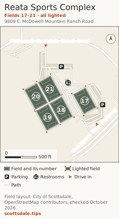
Reata Sports Complex field mapMap of Reata Sports Complex, 9809 E. McDowell Mountain Ranch Road, in the angle between McDowell Mountain Ranch Road and Thompson Peak Parkway. All five fields are lighted. Fields 18 to 21 form a block of four set on the diagonal, split by a walkway that runs from southwest to northeast: Fields 20 and 21 are north of the walkway, 20 to the west, and Fields 19 and 18 are south of it, 19 to the west. Field 17 stands on its own to the east. The restroom and office building is between Field 21 and Field 17. Parking is in the north lot, reached by the drive from McDowell Mountain Ranch Road, and in the east lots along the drive from Thompson Peak Parkway. McDowell Mountain Ranch Park and its aquatic center are across Thompson Peak Parkway to the southeast.Reata Sports ComplexFields 17–21 · all lighted9809 E. McDowell Mountain Ranch Road1718192021McDowell Mountain Ranch RoadThompson Peak ParkwayRestrooms, officePPTo the aquatic center ↘N0500 ftField and its numberLighted fieldPParkingRestroomsDrive inPathField layout: City of Scottsdale,OpenStreetMap contributors, checked October2026scottsdale.tips
Download the field map (SVG, prints at any size). Reata Sports Complex guide . Field numbers match the city’s facility map (PDF); on tournament days the organizer’s map wins.

WestWorld: Field West

WestWorld has no permanent sports fields. Its grass is Field West, the polo field at the Pima Road end of the grounds, entered on WestWorld Road with D Lot beside it. When a tournament plays there, the organizer paints and numbers the fields for that event, so this map shows where the grass is, not where Field 3 will be. Don’t follow event signs to the Equidome and the barns; they’re a mile east at the other end of the grounds.
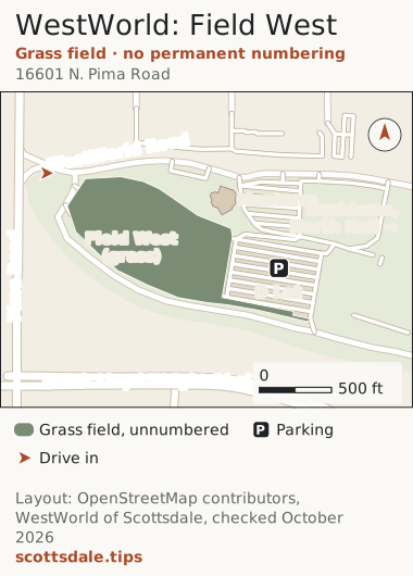
WestWorld: Field West field mapMap of the west end of WestWorld of Scottsdale, 16601 N. Pima Road, beside the Loop 101. WestWorld has no permanent sports fields. Its big grass field, Field West, fills the west end of the grounds south of WestWorld Road, with the paved D Lot to its east. When a tournament uses the grass, the organizer lays out and numbers the fields for that event, so use the organizer’s map for field numbers. Cars come in from Pima Road on WestWorld Road. The Equidome, North Hall and the horse barns are farther east, toward 94th Street.WestWorld: Field WestGrass field · no permanent numbering16601 N. Pima RoadPima RoadWestWorld RoadFrank Lloyd Wright Blvd.Field West(grass)D LotPMonterraEquidome,North Hall →N0500 ftGrass field, unnumberedPParkingDrive inLayout: OpenStreetMap contributors,WestWorld of Scottsdale, checked October2026scottsdale.tips
Download the field map (SVG, prints at any size). WestWorld: Field West guide . Field numbering for WestWorld comes from each event’s organizer.

The fields that aren’t on these maps

  • McDowell Mountain Ranch Park has its own five sports fields along 102nd Way, three rectangles and two ball diamonds, used for local leagues and not numbered on the city’s map. If your schedule says 17 to 21, you want Reata across the parkway.
  • “Salt River” fields are on the Salt River Pima-Maricopa Indian Community, east of the Loop 101, which runs its own facilities; they aren’t part of Scottsdale’s numbering, so the organizer’s map is your only guide there.
  • Pickleball, softball and neighborhood fields are scattered through the city parks; the pickleball note and the parks index cover them.

Game day, in five lines

  1. Check the park, not just the field number. Fields 1–10, 11–16 and 17–21 are three places.
  2. Pick the lot by the field: center lot at the Sports Complex, the 94th Street lot for Bell94’s east fields, the east lots at Reata for 17 and 18.
  3. None of the fields has shade. Bring the canopy, and see the tournament weekend guide for what else the desert asks of you.
  4. In January and February, check the WM Phoenix Open and Barrett-Jackson dates; all four venues sit in their traffic, and Reata and Bell94 double as their overflow parking.
  5. Eat close: The Thumb by Bell94, Flo’s by Reata, La Hacienda up Princess Drive from the Sports Complex, and the best Mexican restaurants list when the team wants tacos.

How these maps were made

The fields, lots, paths and streets come from OpenStreetMap, checked against the City of Scottsdale’s facility maps for the Sports Complex, Bell94 and Reata in October 2026. Where the two disagreed, the city won: OpenStreetMap had no numbers at the Sports Complex, drew Fields 7 to 10 as two shapes and marked only four fields as lighted. Reata is too new to be in OpenStreetMap, so its five fields are drawn from the city’s map, placed on the ground with aerial imagery, at their real 225-by-360-foot size. WestWorld’s field and lot come from OpenStreetMap and WestWorld’s own grounds map. The city’s sports complexes page has the field counts, sizes and booking rules. If you spot a field that has moved, tell us and we’ll redraw it.