
What is Pinnacle Peak Park?
There are bigger mountains in the Valley. There’s no better-shaped one.
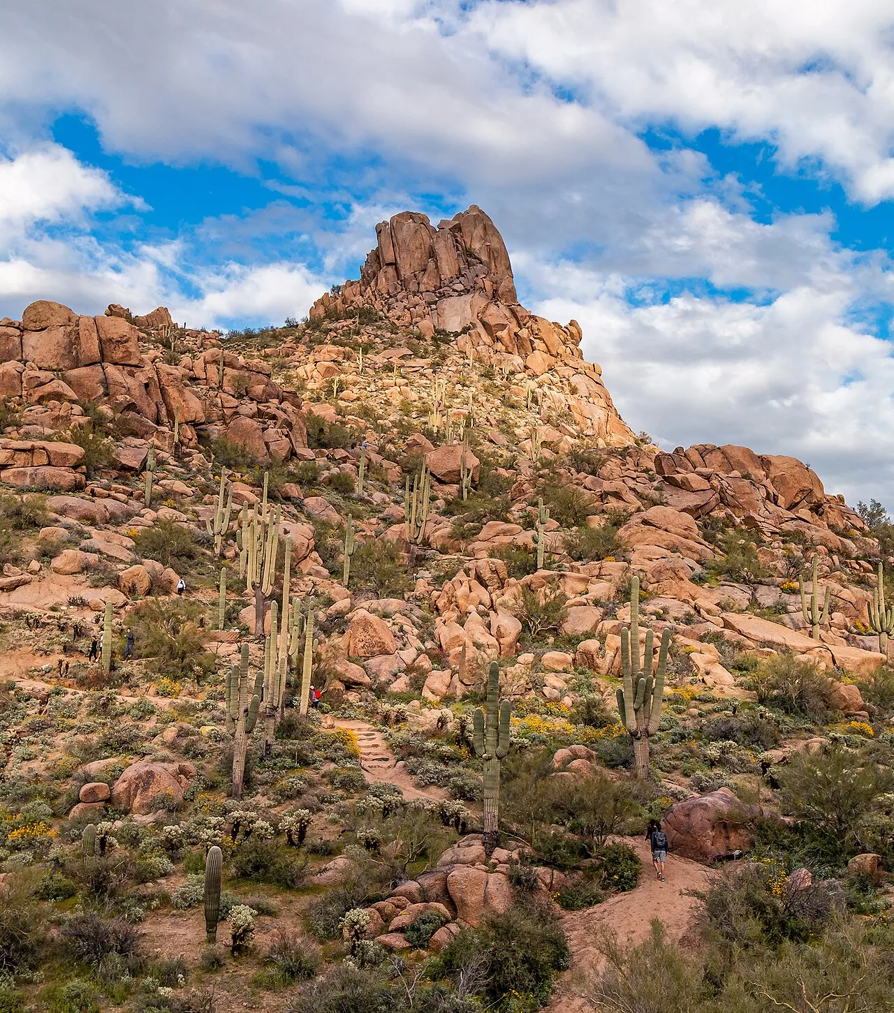
Pinnacle Peak is the granite exclamation point of north Scottsdale — a 3,169-foot spire of weathered boulders that lent its name to a road, a country club, a legendary steakhouse and roughly half the real estate listings north of Happy Valley. Wrapped around it is Pinnacle Peak Park: 150 city-owned acres threaded by exactly one trail, 1.75 miles each way, climbing through some of the best-preserved upper Sonoran Desert you can reach without a trailhead permit.
The formula is stripped-down on purpose. A small staffed trailhead with restrooms, shaded ramada and interpretive displays; a beautifully built path with signs naming the saguaros, teddy-bear cholla and granite formations; established routes for rock climbers on the summit block (the trail itself doesn’t top out — the last pitch is for people with ropes); and rules with teeth: sunrise to sunset, no dogs, no bikes, stay on the trail.
What you get in exchange for the rules is the thing itself: a real desert mountain experience, fifteen minutes from a Starbucks, on a trail good enough that locals treat it as their gym and out-of-towners treat it as their Arizona postcard. On winter mornings the parking lot hosts license plates from a dozen states, all here for the same 3.5 miles.
How to hike it right
The season is the strategy. October through April, this is an any-hour trail — though the small lot fills by mid-morning on weekends. May through September, it’s a dawn trail, full stop: the route is exposed granite and decomposed-granite tread that stores heat like a skillet, and the park’s sunset closure means no cool-evening option. Start at first light, carry more water than a 3.5-mile hike seems to deserve (a liter per person minimum in summer), and be down by 9.
Know the shape of the hike. From the main trailhead at 102nd Way, the trail switchbacks briskly up to a saddle with the classic view — Troon’s fairways below, the McDowells across the way, the whole Valley smeared silver to the horizon — then rolls and descends along the mountain’s far side to the Jomax-side trail end. Most people turn around at or past the saddle viewpoint; going all the way through and back earns you the full 3.5 miles and a second helping of climbing on the return, which surprises people who spent their outbound descent feeling smug.
Respect the closure. “Sunrise to sunset” is enforced with posted seasonal times, a sweep, and a locked gate. Don’t be the headlamp hiker who forces a ranger to come find you.
Climbers: the granite here is the real thing, with long-established routes on the summit blocks. Check in at the trailhead for current access rules.
Pair it well. Pinnacle Peak is the perfect short day — which makes it a natural half of a doubleheader with the McDowell Sonoran Preserve trailheads ten minutes east, or a reward breakfast in Troon. Families with smaller kids who aren’t ready for the climb do better at George “Doc” Cavalliere Park or the splash pad at Florence Ely Nelson Desert Park, both nearby.
The mountain that got fenced off
Here’s the part the postcard leaves out: for about seven years, you couldn’t legally set foot on Pinnacle Peak.
For most of the twentieth century the peak stood in open cattle country, climbed and scrambled by anyone willing to drive the dirt roads — a local landmark with a steakhouse at its feet (the Pinnacle Peak Patio, slinging mesquite-grilled beef and cutting off neckties from 1957 onward) and no gate anywhere. Hikers and rock climbers used it freely through the 1980s, the same decade Scottsdale annexed its northern desert and the master-planned wave arrived: Pinnacle Peak Country Club, Troon Village, Troon North, golf holes threading the boulders.
The informal access had always depended on crossing private land nobody cared about. By 1995, somebody cared. As luxury home construction pressed against the mountain’s base, the peak was closed to the public — the word used at the time was temporarily — and one of the Valley’s signature summits became, functionally, the centerpiece of a gated view corridor. The optics were terrible and everyone knew it: a city named for open desert, watching its most photographed rock disappear behind rooftops.
What followed was slow, unglamorous and ultimately decisive. Through the late ’90s the city worked the problem — negotiating access and boundaries with the surrounding developments, securing the 150-acre park footprint, and building a proper, sustainable trail where the old scramble of social paths had been. On April 20, 2002, Pinnacle Peak Park opened, six-plus years after the gate had swung shut, with public access no longer a neighborly courtesy but a legal fact.
The park’s strictness is the residue of that fight. One trail, no off-trail travel, no dogs, sunset closure, staff on site: these are the terms that made a public mountain compatible with the houses that now stand fifty yards from the trail corridor. It can feel fussy compared with the Preserve’s open-armed 230-mile trail network. It’s also why the saguaros beside this trail are pristine and the granite isn’t tagged.
Why it matters
Pinnacle Peak is the cautionary tale that made Scottsdale serious. The peak was closed in 1995 — the same year Scottsdale voters approved the first sales tax to buy McDowell Sonoran Preserve land. That’s not coincidence; it’s cause and effect. Watching a beloved mountain get locked away in real time did more for open-space politics than any brochure could. The Preserve is the lesson learned at scale. Pinnacle Peak Park is the lesson itself: 150 acres the public got back, one negotiated trail at a time — and a standing reminder, every sunrise when the gate opens, of how close it came to staying closed.